Tannahill Gold Property
Flagship gold exploration asset located ~25 miles northeast of the Kirkland Lake Gold Camp, within Ontario’s prolific Abitibi Greenstone Belt, where historical drilling has defined multiple gold-bearing zones that remain open along strike and at depth.
PROJECT OVERVIEW
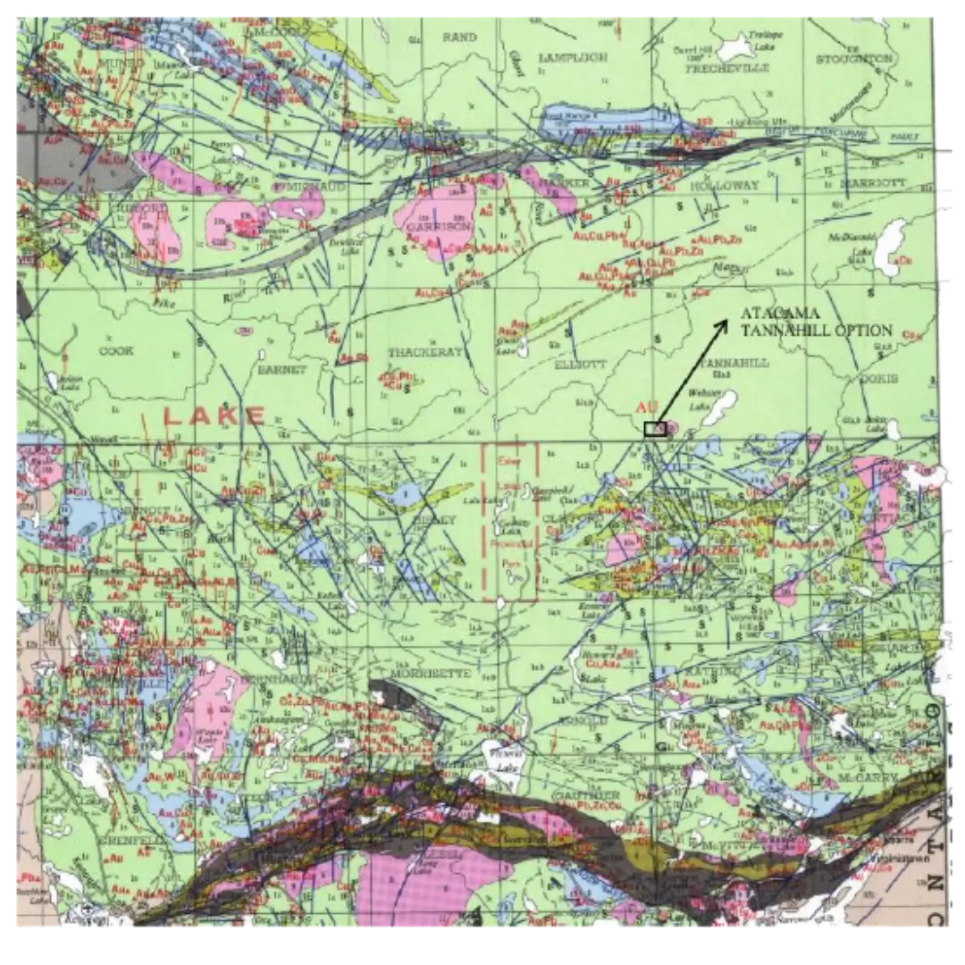
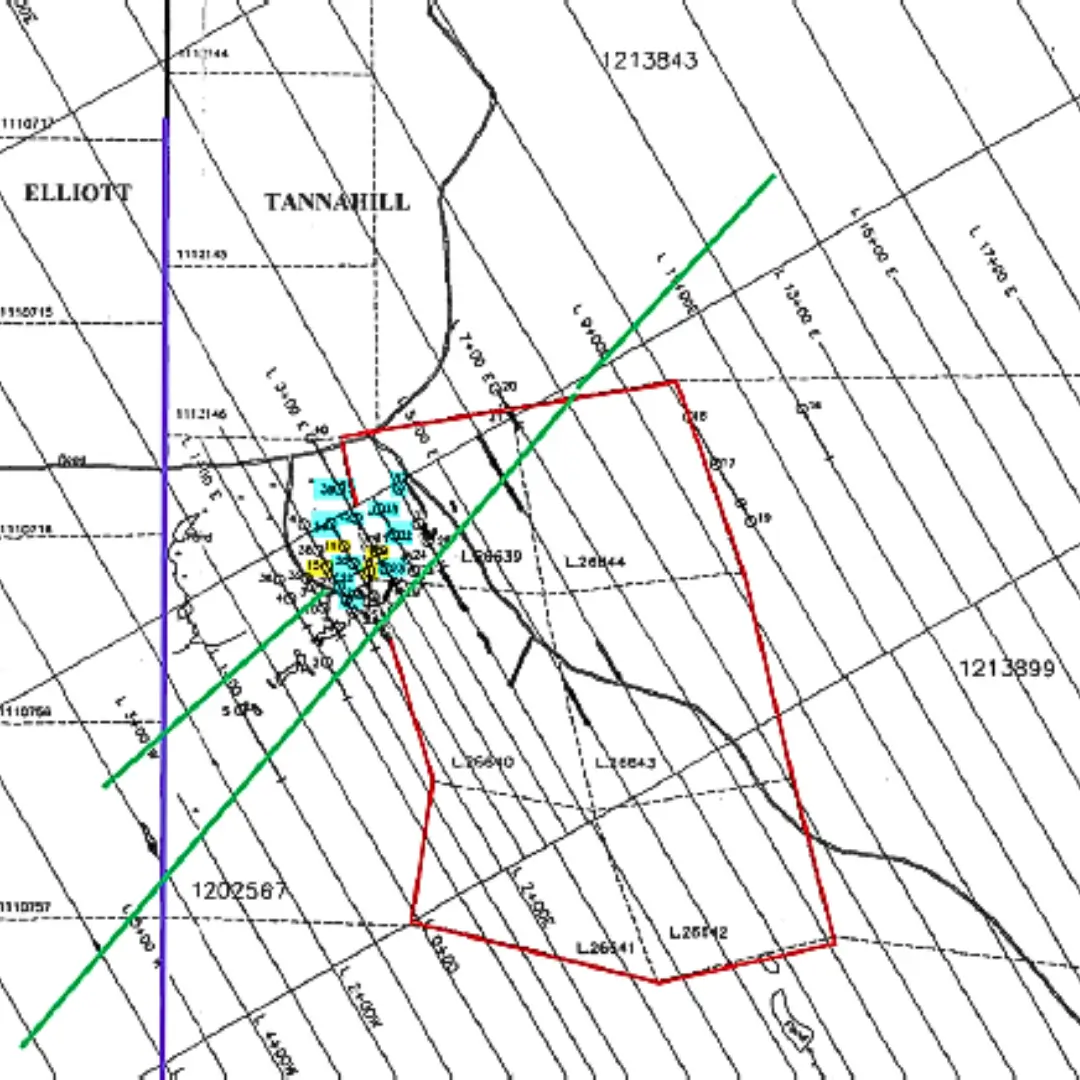
The Tannahill Gold Property represents Atacama Resources’ primary exploration asset, located within the Abitibi Greenstone Belt in northeastern Ontario. The project is situated approximately 25 miles northeast of the Kirkland Lake Gold Camp, one of Canada’s most historically productive gold districts.
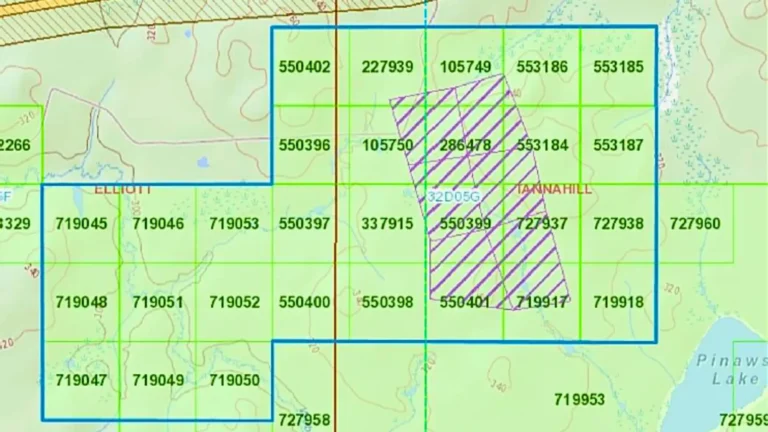
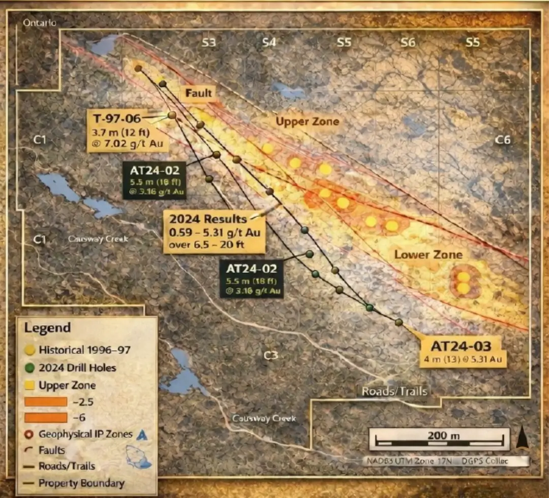
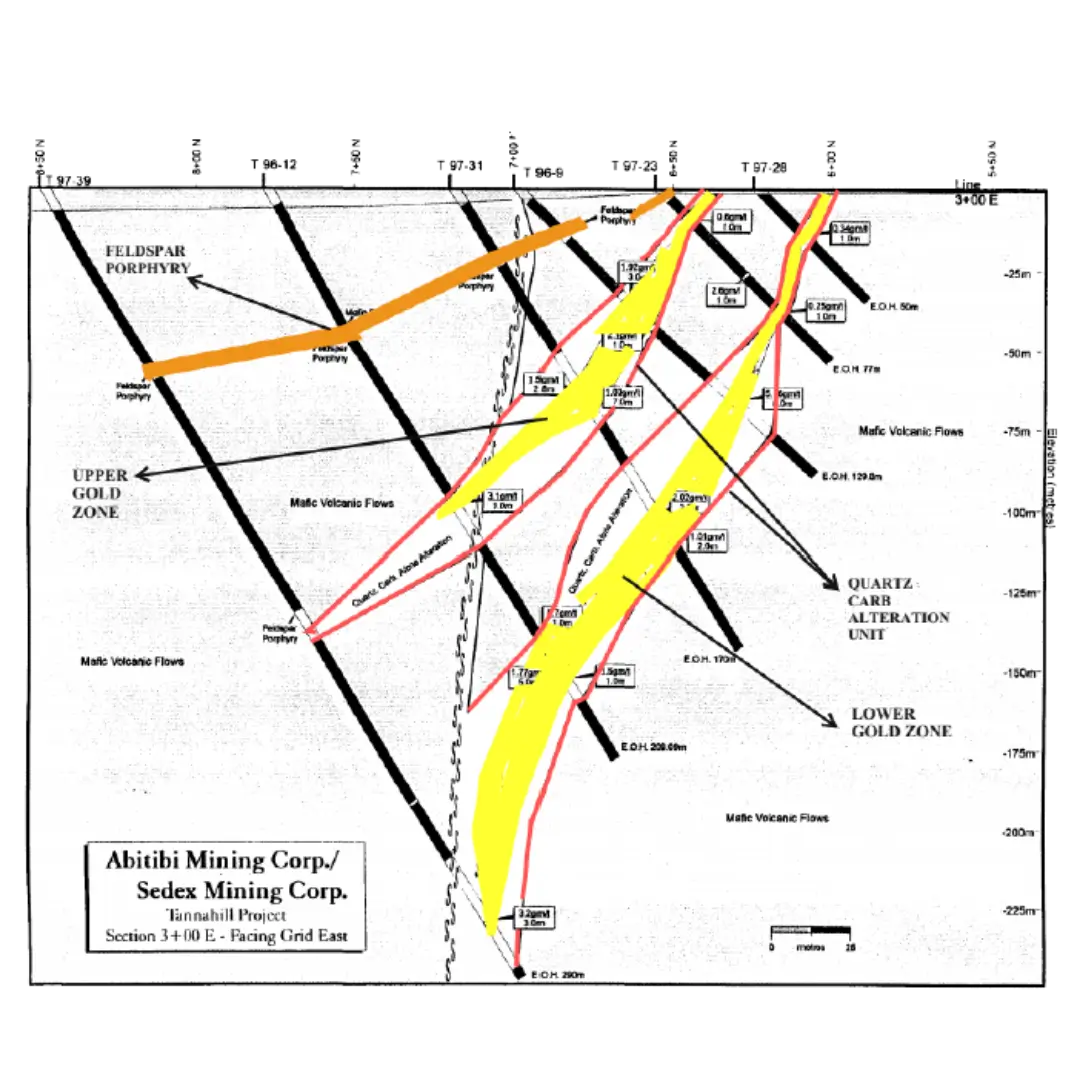
The property consists of 29 contiguous claim units and hosts multiple structurally controlled gold horizons. Historical drilling has identified two parallel gold-bearing zones associated with northeast-trending fault systems, with mineralization observed across a range of widths and grades.
Both zones remain open along strike and at depth, with additional structural targets identified to the southwest of the main mineralized corridor.
Proven Gold-Bearing System
Historical drilling has confirmed two parallel gold-bearing zones associated with northeast-trending fault systems, with mineralization encountered across multiple drill programs and a range of widths and grades.
Structurally Controlled Mineralization
Gold mineralization is hosted within a well-defined structural corridor, with northeast-trending faults intersected by secondary structures—an environment commonly associated with significant gold systems in the Abitibi Greenstone Belt.
High Drill Success Rate
27 of 28 historical drill holes intersected anomalous to significant gold values, demonstrating strong continuity and supporting the presence of a robust mineralized system.
Open Along Strike and at Depth
Both primary gold zones remain open along strike and at depth, with additional targets identified beyond the currently defined mineralized corridor.
District-Scale Exploration Potential
Located approximately 25 miles northeast of the Kirkland Lake Gold Camp, the property benefits from a highly prospective geological setting with potential for expansion across multiple structural targets.
PROJECT SNAPSHOT
LOCATION
Kirkland Lake District, Ontario
LAND POSITION
29 contiguous
claim units
PROXIMITY TO KIRKLAND LAKE CAMP
~25 miles
northeast
REGIONAL SETTING
Abitibi
Greenstone Belt
HISTORICAL DRILLING
40+ drill holes
GOLD-BEARING ZONES
2 parallel horizons
REPORTED INTERCEPTS
Up to 7.02 g/t Au
over 3.7 m
EXPLORATION STAGE
Open along strike
and at depth
PROJECT SUMMARY
A. Location & Jurisdiction
- Located approximately 25 miles northeast of the Kirkland Lake Gold Camp
- Situated within the Abitibi Greenstone Belt, one of the world’s most prolific gold-producing regions
- Access via established regional road networks and infrastructure
- Proximity to historical and active gold operations
B. Geological Context
The Tannahill property is positioned within a structurally significant corridor characterized by northeast-trending fault systems typical of the Abitibi Greenstone Belt. Gold mineralization identified to date is associated with two parallel shear-hosted zones, consistent with regional structural controls observed across the district.
A secondary structural feature trending southwest has been identified and interpreted as intersecting the primary mineralized horizons. This structural intersection presents an additional area of exploration interest and may represent a continuation or extension of the known gold system.
C. Structural Setting / Controls
Lorem ipsum dolor sit amet, consectetur adipiscing elit. Ut elit tellus, luctus nec ullamcorper mattis, pulvinar dapibus leo.
HISTORIC DRILLING & MINERALIZATION
Reported Intercepts
-
- 7.02 g/t Au over 3.7 m
- 5.16 g/t Au over 5.0 m
- 4.80 g/t Au over 5.0 m
Intercepts reported from historical drilling programs targeting primary gold-bearing horizons.
Drill Highlights
-
- Mineralization identified across widths ranging from 1.0 m to 11.0 m
- Visible gold observed in multiple drill holes
- Two parallel, shallow-dipping gold zones defined (Upper & Lower Zones)
- 27 of 28 drill holes intersected anomalous to significant gold values
- Mineralized zones remain open along strike and at depth, indicating expansion potential
EXPLORATION PROGRAM
Geophysical Surveys
Magnetic and induced polarization (IP) surveys have identified chargeability anomalies and resistivity features consistent with sulfide-bearing zones, helping define key subsurface targets.
Structural Targeting
Survey data has delineated a southwest-trending fault system interpreted to intersect primary gold horizons, providing a structural framework for focused exploration.
Drilling Program
Ongoing drilling is focused on evaluating priority targets in the northern portion of the property, with results continuously integrated to refine geological interpretation.
PROJECT STATUS
With historical drilling confirming strong gold mineralization, the next phase of work is focused on expanding and refining known zones through disciplined drilling and targeted geophysical surveys to unlock the project’s next stage of growth.
-
- Continued drilling along the northeast structural trend
-
- Objective: advance the project toward potential future resource delineation through systematic drilling and structural targeting
-
- Testing deeper extensions and structural intersections
-
- Follow-up geophysical surveys to refine priority targets
ADDITIONAL EXPLORATION ASSETS
RESOURCES
Investor Presentation
Access the company’s investor presentation